Ellis County, Texas
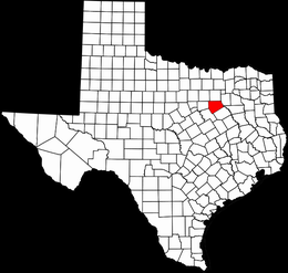 Ellis County is located in north central Texas. The county is bounded by Dallas County to the north, Kaufman to the east, Navarro and Hill counties to the south, and Johnson County to the west. The center point of the county is at
32°21' north latitude and 96°48' west longitude. Ellis County comprises 939 square miles of the Blackland Prairie. Away from the streams it is almost treeless except for scattered mesquite, cacti, and shrubs. Native vegetation
consists mainly of bunch and short grasses, including Indian, buffalo, grama, big and little bluestems, and three-awn. Such native trees as ash, cottonwood, pecan, hackberry, bois d'arc, oak, and elm grow along watercourses. The terrain
is level to rolling, with an elevation ranging from 300 to 700 feet above sea level. The area lies in a southeastward-sloping plain and is well drained by many streams that flow into the Trinity River, which forms the eastern boundary of the county. Red Oak, Waxahachie, Mill, and Chambers creeks drain most of the county. The Austin Escarpment, a high chalk ridge, extends in a northeast-southwest direction and cuts off drainage to the southeast. Mountain Creek flows northeast and drains the northwestern part of the county. The soilspredominantly calcareous, marly and variegated clays and clay loamshave average to good moisture retention and are underlain by a water supply
sufficient for livestock, irrigation, and domestic purposes. The alluvial soils are mainly clay. Temperatures range from an average low of 35° F in January to an average high of 96° in July, rainfall averages slightly less than thirty-six inches a year.
Ellis County is located in north central Texas. The county is bounded by Dallas County to the north, Kaufman to the east, Navarro and Hill counties to the south, and Johnson County to the west. The center point of the county is at
32°21' north latitude and 96°48' west longitude. Ellis County comprises 939 square miles of the Blackland Prairie. Away from the streams it is almost treeless except for scattered mesquite, cacti, and shrubs. Native vegetation
consists mainly of bunch and short grasses, including Indian, buffalo, grama, big and little bluestems, and three-awn. Such native trees as ash, cottonwood, pecan, hackberry, bois d'arc, oak, and elm grow along watercourses. The terrain
is level to rolling, with an elevation ranging from 300 to 700 feet above sea level. The area lies in a southeastward-sloping plain and is well drained by many streams that flow into the Trinity River, which forms the eastern boundary of the county. Red Oak, Waxahachie, Mill, and Chambers creeks drain most of the county. The Austin Escarpment, a high chalk ridge, extends in a northeast-southwest direction and cuts off drainage to the southeast. Mountain Creek flows northeast and drains the northwestern part of the county. The soilspredominantly calcareous, marly and variegated clays and clay loamshave average to good moisture retention and are underlain by a water supply
sufficient for livestock, irrigation, and domestic purposes. The alluvial soils are mainly clay. Temperatures range from an average low of 35° F in January to an average high of 96° in July, rainfall averages slightly less than thirty-six inches a year.